Measuring exposure to pollution through your phone
What’s the best way to measure human exposure to urban pollution? Typically, cities do so by studying air-quality levels in fixed places. New York City, for example, has an extensive monitoring network that measures air quality in 155 locations. But now a study led by MIT researchers, focused on New York City, suggests that using mobile-phone data to track people’s movement provides an even deeper picture of exposure to pollution in urban settings.
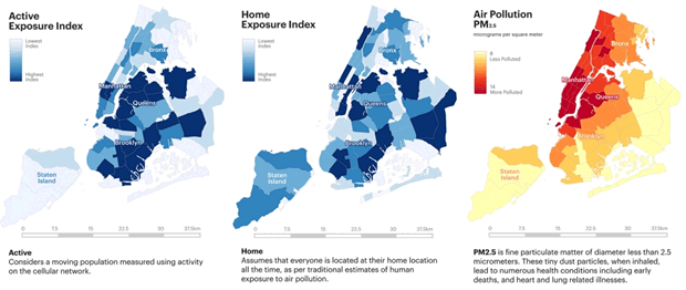
The study, based on data from 2013, broke New York City into 71 districts and found that in 68 of them, exposure levels to Particulate Matter (PM) were significantly different when the daily movement of 8.5 million people was accounted for.
Specifically, the flow of people into parts of midtown Manhattan, and some parts of Brooklyn and Queens close to Manhattan, appeared to increase aggregate exposure to PM in those areas. Meanwhile, the daytime movement of people away from Staten Island actually lowered overall exposure levels in that borough.
“The traditional way to look at pollution is to have a few measurement stations and use those to look at pollution levels,” says Carlo Ratti, a professor of the practice in MIT’s Department of Urban Studies and Planning, and director of MIT’s Senseable City Lab, where the study was conducted. “But that’s sensitive to where the [measuring] stations are. If you want to quantify exposure, you also need to know where people are.”
The researchers believe the method in the study can be applied broadly and create new levels of detail in an important realm of urban and environmental analysis.
“Up to now, much of our understanding of the impact of air pollution on population health has been based on the relationship between air quality and mortality and/or morbidity rates, in a population which is assumed to be at their home location all the time,” says Marguerite Nyhan, a researcher at Harvard’s T.H. Chan School of Public Health, who led the study as a postdoctoral researcher at the Senseable City Lab. “Accounting for the movements of people will improve our understanding of this relationship. The findings will be important for future population health assessments.”
The paper, “Exposure Track: The Impact of Mobile-Device-Based Mobility Patterns on Quantifying Population Exposure to Air Pollution,” is published this month in the journal Environmental Science & Technology.
The co-authors are Nyhan; Ratti; Rex Britter, a visiting scientist at the Senseable City Lab, who helped direct the project with Ratti; Sebastian Grauwin, a former researcher at the Senseable City Lab; Bruce Misstear and Aonghus McNabola, both engineering professors at Trinity College Dublin; Francine Laden, a professor in Harvard’s T.C. Chen School of Public Health; and Steven R.H. Barrett, the Leonardo-Finmeccanica Associate Professor in MIT’s Department of Aeronautics and Astronautics. Nyhan is the corresponding author.
To conduct the study, the researchers examined 121 days of data from April through July 2013, using many types of wireless devices from a variety of providers, and blending the phone data with pollution information from the New York City Community Air Survey.
The result, Ratti notes, is effectively “two different maps” representing exposure to PM, one showing the exposure that a static, home-based population would have, and the other showing the actual exposure levels given the dynamics of urban mobility.
By analysing the issue in this form, the researchers believe they have demonstrated a new way for city leaders, health officials, and urban planners to obtain data on pollution levels and analyse their policy options.
“It becomes an interesting tool if you are a mayor and you want to take action,” Ratti says. “Your goal is to minimise exposure. And exposure is a key determinant of human health.”
The study, the researchers suggest, also underscores the significance of analyzing transportation systems in cities. After all, while some of the PM pollution may come from fixed industrial sources, some of it also comes from automobiles. Studies like this one could help planners identify key locations for low emissions zones, congestion charging, and other tools cities have begun using in an attempt to reduce aggregate exposure among people.
“You’ve got this interplay between moving sources of pollution and the movement of people,” Ratti observes. The technology firm Ericsson provided data for use in the study and provides support for the Senseable City Lab.
Product Spotlight
APV1111GVY
Panasonic
Panasonic PhotoMOS® Photovoltaic MOSFET High-Power Drivers
| SKU: | |
|---|---|
| Stock: | 3490 |
| Cost: | $3.95 |